By Roland Murphy for AZBEX
In its meeting this week, the Pinal County Planning and Zoning Commission will consider a request by Pinal County to rezone more than 3,200 acres in unincorporated San Tan Valley to allow for future development.
The County submitted the application on behalf of the Arizona State Land Department to ready the property for a potential future land auction, or multiple auctions, depending on what developers and development types may find the area of interest.
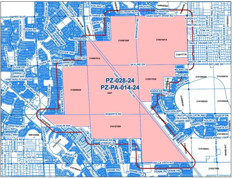
Covering 3,238.7 acres, the site lies between Hash Knife Draw Road to the north, Bella Vista Drive to the south, Schnepf Road to the east, and Hunt Highway to the west in the unincorporated San Tan Valley area of the county. It is roughly bisected on a northwest to southeast line by Gantzel Road.
The site is located approximately 10 miles south of Queen Creek and 25 miles north of Florence. The Gila River Indian Community sits five miles north and eight miles west.
The land is currently covered by a variety of different land use designations. According to the submitted project narrative, “This request is being submitted by Pinal County on behalf of ASLD to provide a “Special District” land use designation in accordance with the Pinal County Comprehensive Plan, which would allow for the processing of zoning entitlements on State Trust land. The current land use designations are Suburban Neighborhood, Urban Transition, Urban Center and Suburban Office in the San Tan Valley Special Area Plan. The request is to designate the entire 3,238.7± acre site to ‘Special District’. Accompanying this request is an application to rezone the property in question to the Large Master Planned Community zoning for the approximately 3,238.7-acre area. The proposal for L-MPC zoning will provide a framework for managing and regulating the density, intensity, zoning and development on the ASLD land over the next decade.”
The two requests before the Commission consist of a non-major Comprehensive Plan amendment and a rezoning from General Rural to L-MPC to establish the master-planned community area.
Given its large area, the location is served by several different roads. “Gantzel Road, providing access to Hunt Highway, is a key regional transportation corridor, and the Union Pacific Railroad alignment approximately splits the Property in half and runs diagonally through the Property from the northwest to the southeast,” the narrative says.
It adds the property is also “ideally positioned for future development.” Major existing and planned transportation corridors near the site include Hunt Highway, the planned Central Arizona Parkway, a planned extension of State Route 24, Skyline Drive and the planned North-South Corridor that will connect US 60 and Interstate 10.
The location consists of entirely undeveloped desert and agricultural land with no habitable structures, according to the submittal. Surrounding uses are agricultural and single-family residential.
Timing and Purpose
The area under consideration, like nearly all of Pinal County, has experienced significant population and employment growth in the last several years.
San Tan Valley residents have expressed an interest in incorporating. According to the submittal, “The rapidly increasing population of San Tan Valley and the desire and need for more urban level services has brought the issue of incorporation of San Tan Valley to the forefront. In 2024, an Incorporation Committee was formed, and the committee members have been seeking support for incorporation as well as developing the blueprint for an incorporation vote of San Tan Valley registered voters in August 2025. On October 30, 2024, the Pinal (County) Board of Supervisors authorized the circulation of the required petition seeking 10% of the signatures of qualified electors residing within the proposed town boundaries.”
The ASLD property would be within the incorporation boundaries. The narrative says the included properties are essential for effective land use and transportation planning.
“Thus,” it says, “Pinal County is seeking the zoning entitlements on behalf of the incorporation effort currently. Equally important, the zoning entitlement work is important at this time for planning the future development of the area, with or without incorporation of San Tan Valley.”
The land owner is the Arizona State Land Department, and Pinal County is the applicant. Consultants for the process are Swaback Partners and WOODPATEL.


