By Roland Murphy for AZBEX
Plans for a major master-planned growth area in north Peoria continue to make quick progress.
Local news outlets reported Peoria City Council approved the required General Plan amendments needed for the two major components in north Peoria’s expansion: North Peoria Gateway and the Peoria Innovation Core.
Approximately 75% of Peoria’s vacant land is owned by the Arizona State Land Department. The GPAs create two master-planned areas and will force the creation of Planned Community Developments. The City will work with ASLD to entitle the land and make it available for development.
Planning and Zoning Acts on NPG Requests
In its Sept. 19 meeting, the Peoria Planning and Zoning Commission took its own efforts to move the North Peoria Gateway proposals forward, recommending two zoning requests for approval.
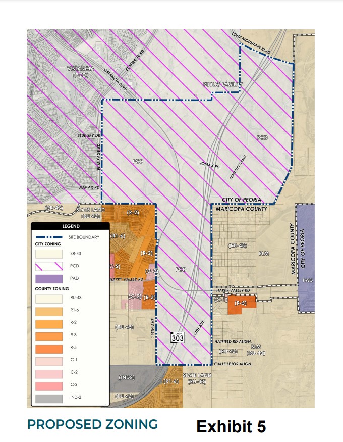
The first request was an initial zoning covering 460 acres under consideration for annexation. The proposal will change the site from Maricopa County Rural Residential 43 (RU-43) to the City of Peoria Suburban Ranch 43 (SR-43). According to the agenda, “The proposed Initial Zoning would convey equivalent zoning on the property subsequent to annexation compared to the existing zoning within Maricopa County. The property is generally located between the Jomax Road, Calle Lejos, 115th Avenue, and 119th Avenue alignments.”
Initial zoning must be assigned to a property within six months of the effective date of an annexation under state law.
The second item will rezone approximately 1,620 acres from Suburban Ranch to North Peoria Gateway Planned Community District for the mixed-use master-planned development. The site is located on both sides of Loop 303 and runs from south of Lone Mountain Parkway to the Calle Lejos alignment.
The submitted narrative for the rezoning request, submitted by RVi Planning + Landscape Architecture on behalf of ASLD, outlines two requests: This application represents a request to facilitate the rezoning of approximately 1,618 acres of and the annexation of 458 acres of State Trust Land located generally at the intersection of Jomax Road and the Loop 303 Freeway (“Site” or “Property”). The majority of the Site is within the jurisdictional authority of the City of Peoria, with approximately 458 acres currently within Maricopa County. The request seeks the following:
- Annexation of 458 acres from Maricopa County into the City of Peoria
- Rezone the overall property to Planned Community District (“PCD”) to allow for a variety of residential and non-residential land use types.
The narrative cites the recent GPA as providing guidance the planned North Peoria Gateway development, saying the General Plan, “‘…provides flexibility to promote new development needed to accommodate economic growth and new businesses so that residents can find jobs in Peoria. The category also provides opportunity for new housing to accommodate Peoria’s expanding population…’ This use designation will apply to the entirety of the subject property.”
No master developer is associated with the plan yet. The rezoning and associated requests are intended to move the site to market-ready conditions to facilitate development when the components are in place.
As currently envisioned, the site will be divided into six development units ranging between 180.6 acres and 480.5 acres. Land uses and development types will contain a corresponding mix in each development unit and will range from single-family and low-density residential to high-density multifamily, commercial, mixed-use and full-scale employment center uses with the intent to create a coherent flow across development and usage types.
Opposition and Justifications Expressed
As with nearly any planned redevelopment, some nearby residents have expressed opposition to the proposals. Specific concerns include worries about potential traffic impacts, drainage and water use, harm to native wildlife habitats, fear of “uncontrolled development,” a potential decrease in property values, and harm to “neighborhood character.”
In justifying the rezoning request, however, the narrative says, “The proposed rezoning request envisions a diverse mix of land uses for the subject property that are in alignment with the City’s General Plan. The plan creates opportunities for future residential communities, employment-oriented uses and commercial/retail centers. This broad range of uses and intensity types are appropriate given the proximity of the site to the Loop 303 Freeway corridors that provides access to a regional transportation network.”
The development area is currently owned by the Arizona State Land Department. RVi Planning + Landscape Architecture is the land planner. The civil engineer is Ardurra, and the project is represented by Bergin, Frakes, Smalley & Oberholtzer, PLLC.


